Quickstart guideYou can log in to atlasbiowork.com using your Google, Facebook, and Twitter identities, and we will not share your email or identities, but use them only for your login. If these logins don't work for you, we can supply you with a username and password on request. Contact Peter at managingwholes.com@gmail.comAtlasbiowork.com is a web app for data entry around soil health and watershed function. It provides a free and fairly simple way to connect observations and measurements with photographs and site locations--for example with a smartphone--and for presenting these on maps. Web apps or web applications work in a browser such as Chrome or Safari, and on devices ranging from smartphones to desktop computers. Modern browsers can store data, including some photographs, while offline or off network, so it is possible to use web apps on mobile devices to collect data where there is no cell signal or wifi. Before you try to do this with atlasbiowork.com, you must choose "Add to Home Screen" when you are connected to atlasbiowork.com while online. Then you can open the app and collect data without a network connection. (If your connection is poor or intermittent, it may be best to turn your device to airplane mode to avoid confusion between online and offline modes.) Mobile devices using web apps may encounter some limitations, but it's possible to do a good job of data entry. A spare battery, as well as a notebook and pencil for backup, are recommended. If you use the app a good deal, it may be necessary to periodically clear out your browser's storage for atlasbiowork.com. It is also a good idea with a web app to not be too hasty or impatient with button presses, as it may take time for photos to upload, and for screens to update, and pressing again may cause duplicated data to be submitted. The Home screen is both the start screen and menu for the app. Before you can post data or record an observation with atlasbiowork.com, you must be logged in. You may login using Google or Twitter, or you may request a password from us (contact info below). In your first use of atlasbiowork.com, you will be asked to Allow your location to be passed to the app. You must click OK if you would like to record locations using your device's GPS (global positioning system). All observations entered must be connected to a location or Site. This is commonly a point, with latitude and longitude coordinates, but it can also be a line or polygon. For a new point site, choose "New Point Site + Observation" and follow the prompts. Your device should locate you (if it doesn't have a GPS, the location will reflect the location of your network connection) and show you as a point on a map. You must choose a name for the site. When you select Continue, you will see a menu of observation types to choose from. To enter an observation for a site that already been entered, visit the Sites list from the main menu. You can select the site from the list, or from the map, or from another observation on the site. Choose Add Observation. Here's an overview of the data model:
|
The Atlas of Biological Work app framework is for easy data entry and mapping of observations of landscape function such as water infiltration, biomass production or yield, soil tests including soil carbon, soil health indicators, and soil cover.
This framework is designed to help land managers, communities, and regions organize their assets and resources (people, their creativity, innovation, and land stewardship, the work they've done, possibilities they've realized, programs and funding, data) toward a shared, evidence-based intelligence on soil health and watershed function, especially change over time. It's hard to take responsibility for these functions if we can't see them, or share our observations.
What it is not: Prediction, forecasting, modeling, theory, advocacy of particular practices, problem-oriented fixes, or accumulation of information without a context of action or responsibility.
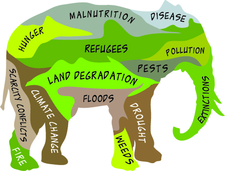 As our challenges with soil function grow, along with awareness of them and the possibilities for overcoming them, we need to see where we are and where we're going. It's like the weather, or sports or politics even, and it could be reported similarly. If weather data were kept private, we could gain little sense of how events are connected, what changes are occurring, or when we might choose to cut hay, shear sheep, plan an outing, or let water out of the reservoir.
Taking responsibility for soil health and watershed function requires a shared intelligence, based on evidence:
- open source, free to use and adapt
- flexible data schema to accommodate broad participation, local situations, and legacy or existing data
- oriented toward repeatable observations with user-chosen methods
- data is not in silos, but can be layered (e.g. as GeoJSON in Leaflet) with multiple other data sources on interactive, citizen-usable maps
 |
|
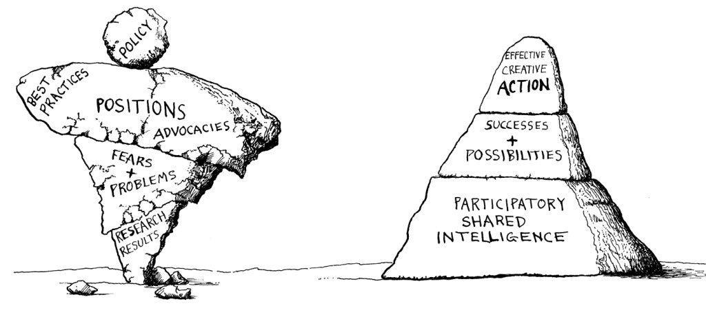
| Problem-oriented: When dealing with complexity, this structure turns risky. Positions, predictions, and advocacies overshadow the evidence. Fragmentation is guaranteed, and there is little accountability for results. Diversity is a threat. | Opportunity-oriented: diversity of framings and contexts, and wider participation by both people and land, become assets to a shared intelligence based on local evidence. |
Atlasbiowork is a framework or scaffold for the pyramid on the right. Contact us for advice on helping your community organize its assets toward a shared intelligence.
Screencast part 0: overview, purpose, design
Screencast part 1: purpose and design
Screencast part 2: basic tips on use
Part of our Atlas of Biological Work, which will offer tools, utilities, and some data sets to map function and changes in function over time, help communities take informed responsibility for the function of their watersheds, and engage others with easily interpreted visual representations of biophysical reality.
You may use it as a web app: go to atlasbiowork.com and Save as Favorite, Save on Home Screen or whatever the proper command for your system is. Once you do this, the app should be available and work without a network connection.
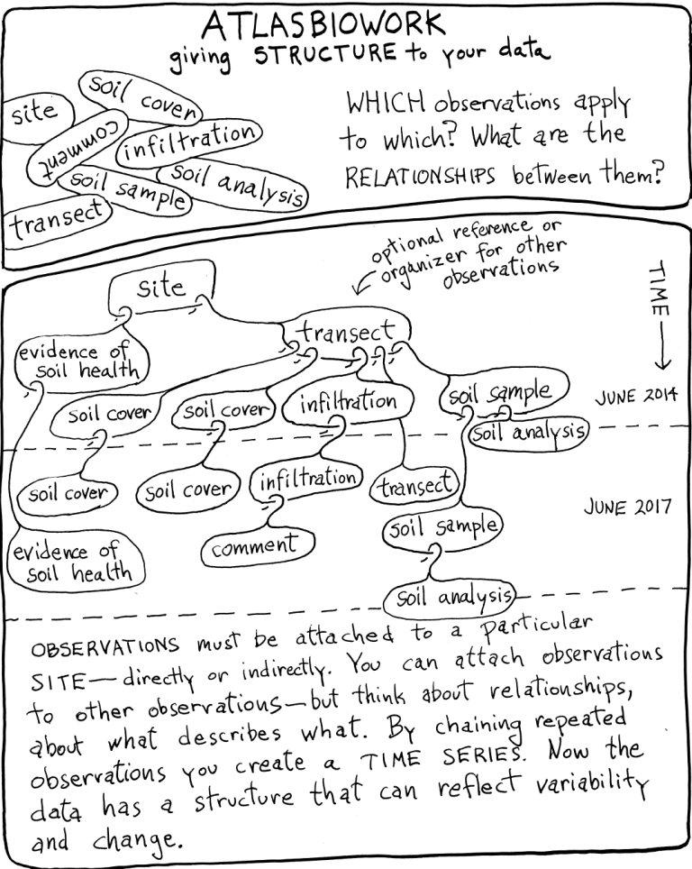
Data entered with this app is publicly visible on a map. Using this app, you are monitoring the work of living organisms (force times distance, usually in chemical terms) and this involves change over time, or a time series: baseline followed by subsequent observations. In order for observations to be repeatable, they must have these characteristics:
- location
- practical, affordable, and accurate enough
- open data: mapped, easily interpretable
- people willing and able to make and record the observations
Instructions for use
The atlasbiowork.com app is a web app which should work on any device with a modern browser (Chrome, Firefox, Safari, etc.). In order to use it offline you must Add to Home Screen, Save as Favorite, or whatever the correct choice is for your system.
Basic procedure: You enter data using your device, and sync (synchronize or upload) to our public, mapped database. Appropriate devices include smartphones, tablets, computers. In the field, a device with GPS receiver and forward-facing camera is desirable, along with backups such as pencil and paper and auxiliary battery.
LOGIN: Users must be authorized to submit data. You may login using Google, Facebook, or Twitter accounts, and you may also request a username and password from us if those don't work for you.
PERMISSIONS: The app will request permission to use your location, and perhaps your camera. Choose Allow to use these features.
PRIVACY: All submitted data is open and public, with your username visible but not your email. Site administrators have access to your email.
DATA: All observations must be connected to a Site. A site can be a point, line, area, or combination. For a point site, the simplest is to choose "New Site + Observation" from the Home page of atlasbiowork.com. For area sites, choose "New Site," outline the polygon using the toolbar on the left, and then you can attach an observation to it.
OBSERVATIONS can also be connected to each other in parent-child relationships, although they can be simply attached to a site as well. If you take a photo in 2016, and repeat that photo in 2017, the later photo should be attached as a child or subsequent observation to the original photo observation. Likewise, a comment on an observation should be attached to the observation it is commenting on. Our data model is thus a "tree" or hierarchy, with the Site as the root or trunk, and observations as branches, twigs, and leaves.
OBSERVATION TYPES currently are about 10, but it is easy for us to edit them or add more. The framework can also be customized as everything is open source. Our Github page is here.
SHARING DATA. Our website is its own API, and sharing data is easy. If you add ".json" or ".geojson" to any url (e.g. atlasbiowork.com/observations.geojson) you will be able to map the data on your own site if you wish. Layering with other data and correlations are all possible.
MAKING OBSERVATIONS. Our guide and the older version give some step-by-step advice for making most of these observations. Other methods are possible too! Keep in mind the need for place-based repeatability: methods should be well documented and be sure to record raw data. See also the learning resources at http://soilcarboncoalition.org/learn