"Conservation Matters" from the Wilson County Citizen (Fredonia, Kansas)
How long does it take an inch of water to soak into the soil? This last week I've been asking that question, showing people a simple infiltration test: a 6-inch section of 6-inch pipe driven halfway in, and an inch of water. Because of recent heavy rains that saturated the surface, and the fine texture (clay and silt) of many local soils, water infiltration on some croplands and even grasslands was extremely slow, often over 90 minutes for the soil to accept an inch of water.
An infiltration test--and they can vary a lot between one place and another, even a foot apart--gives a rough idea of how much water might run off when it rains. It is also possible to look at this runoff ratio over time for an entire watershed by processing rain and stream gauge data. I did this for the Fall River watershed, using USGS flow data from the gauge south of Fredonia, and precipitation data averaged from gauges with available data at Fredonia, Fall River Lake, Eureka, and Climax. The runoff ratio, the fraction of precipitation that is discharged from the river, is annual flow at the gauge at Fredonia divided by the calculated annual precipitation in the watershed. This figure jumps up and down quite a bit, so I made a chart of the 10-year rolling mean or moving average to better see the trend:
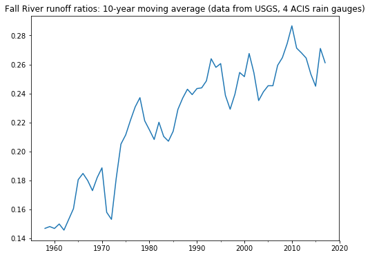
By 1958, the 10-year moving average runoff ratio was about 15%: about 15 percent of what fell as precipitation ended up in the river. By 2018, the 10-year moving average was about 25%: a quarter of what fell as precipitation ran off the land and past the USGS river gauge south of Fredonia.
Over this 60-year period, average annual precipitation has risen, but only by a few percentage points. Runoff ratios increase with increased precipitation, but here we have a large increase in runoff ratios. This difference is about 100,000 acre-feet of water, or about 5 times the current storage capacity of Fall River Lake, that the soils in this watershed are no longer accepting or holding each year.
In 1958, the 10-year rolling mean or moving average of annual flow at the gauge near Fredonia was 256,553 acre-feet. In 2018 it was 359,290 acre-feet. These heavier runoffs move soil. According to Kansas Water Office figures (kwo.ks.gov/reservoirs), Fall River Lake has accumulated sediment equal in volume to the top foot of 17 sections of land since the construction of the dam 70 years ago. Toronto Lake on the Verdigris has accumulated sediment equal in volume to the top foot of about 20 sections of land. I'm glad to share these figures, and how they were arrived at, with anyone interested.
Can this lost infiltration capacity be recovered? Can more rainfall be captured where it falls, or held longer? This could mean lower costs for road maintenance, road repair, water treatment, sediment removal, and perhaps lessened risks from flooding.
The term soil health comes in part from the rediscovery or reclamation of older concepts such as tilth and soil quality. Now there is growing interest in soil biological activity and its sensitivity to management practices such as cover crops, multi-species covers and rotations, reduced tillage, and managed grazing--embodying the soil health principles of cover, living roots, diversity, minimizing tillage, and integration of livestock. It's great to see some farmers and graziers in these watersheds putting these principles into practice, which comes from a commitment to stewardship of the land combined with an entrepreneurial interest in allying their work with the work of sunlight, rain, and the diversity of life, and reducing their input costs.
Life in the soil is all about capturing sunlight energy in the form of water and food: soil moisture from rain, and carbohydrates from plant photosynthesis. With all our complicated technology, with overwhelming amounts of information, political positioning, and salesmanship, it's easy to lose sight of these simple facts about the circle of life, its power, and the work it does for us.
I'm working with the Wilson County Soil and Water Conservation District for the remainder of this week. I'm available to demonstrate simple infiltration measurements and how to record this data.
See also satellite map showing length of green season for Fall River and Upper Verdigris watersheds.
Recent Posts
Archive
Categories
- Events (2)
- policy and framing (23)
- ruminations (3)
Tags
- atlas (2)
Authors
- Peter Donovan (137)
- Didi Pershouse (3)